Modeling Irregular Shapes by Using Interpolation and Image Data
Application ID: 55641
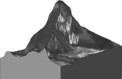
This file shows how to create a surface of an irregular shape based on text, image, or elevation data. This approach is best suited for data where the height (or elevation) is a function of x- and y-coordinates.
The data is of the Matterhorn, a European mountain located in the Alps.
In short, the procedure includes:
- Importing a text file, image file, or elevation data into a function feature
- Creating a parametric surface
- Uniting the surface with a solid
- Removing domains (optional)
Learn more in this blog post: "How to Build Geometries from Elevation Data to Model Irregular Shapes"
この model の例は, 通常次の製品を使用して構築されるこのタイプのアプリケーションを示しています.
ただし, これを完全に定義およびモデル化するには, 追加の製品が必要になる場合があります. さらに, この例は, 次の製品の組み合わせのコンポーネントを使用して定義およびモデル化することもできます.
アプリケーションのモデリングに必要な COMSOL® 製品の組み合わせは, 境界条件, 材料特性, フィジックスインターフェース, パーツライブラリなど, いくつかの要因によって異なります. 特定の機能が複数の製品に共通している場合もあります. お客様のモデリングニーズに適した製品の組み合わせを決定するために, 製品仕様一覧 を確認し, 無償のトライアルライセンスをご利用ください. COMSOL セールスおよびサポートチームでは, この件に関するご質問にお答えしています.